Map of the British Province of New Brunswick 1859
- Contributing Institution
- Maine State Library
- Repository
- Special Collections
- View at Contributing Institution
- https://digitalmaine.com/maps/110/
- Digitization Status
- Digitized / Numérisé(e)
- Identifier/Call Number
- CA859WI001
- Collection/Part of
- Map Collections at the Maine Cultural Building
- Description
- en 
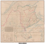
From the best existing materials; by authority of the provincial legislature with Adjacent parts of Canada, Nova Scotia and Maine compile and drawn by John Wilkinson, surveyor and civil engineer, associate of the Institution of Civil Engineers. A.D. 1859
- Author/Creator
- Wilkinson, John
- Date(s)
- 1859
- Genre
- en maps
- Topic & Theme
- American Experience/Américanité
- US-Canada Border/Frontière américaine
- Pre-migration/Au Canada
- Source Language
- English
- Copyright Statement and Conditions governing use
- No Copyright - United States. URI: http://rightsstatements.org/vocab/NoC-US/1.0/
- Existence and Location of Originals
- Maine State Library, Augusta, Maine
- Extent
- 1 map
- Recommended Citation
- Wilkinson, John, "Map of the British Province of New Brunswick 1859." Map Collections at the Maine Cultural Building. https://digitalmaine.com/maps/110/.
- Media
-
msl_map110.jpeg
- Contributing Institution
- Maine State Library
- Repository
- Special Collections
- View at Contributing Institution
- https://digitalmaine.com/maps/110/
- Digitization Status
- Digitized / Numérisé(e)